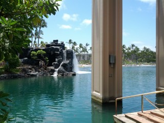
Vacation photos
As promised, here are links to some of my better photos from my recent Hawaii / San Francisco vacation.
Akaka Falls and Hilo – mostly interesting plants.
Hawai’i Volcanoes National Park – volcanic landscapes.
Photos of the transit of Venus.
Miscellaneous San Francisco stuff.
San Francisco
After our week in Hawaii, Frink and I spent two days in San Francisco on our way home, to see a few of the major sights and case the place out for a possible return visit later.
Our plans got a little upset when the Testicle Squeezing Authority held Frink back at the airport in Hawaii – apparently they had never seen a keyboard in anyone’s luggage before. As a result he arrived at a ridiculous hour of the morning and in need of sleep, so we got off to a late start on our first day.
We had a list of restaurants we wanted to try, so the first order of business was breakfast at Gott’s Roadside at the Ferry Building downtown. Their burgers and shakes are pretty darn good but not better than what we can get at home.
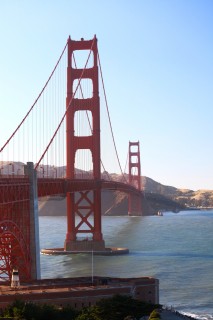
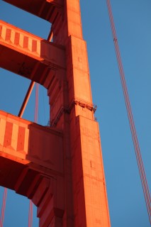
After that and a bit of walking around downtown, we headed out to see the Golden Gate Bridge. It was nice – that’s all I can say about it really. It’s a big, long bridge with some nice art deco detailing on it, and a plethora of anti-suicide measures. I guess if you’re in San Francisco and you want to off yourself, it’s pretty obvious where to go.
Unfortunately that was pretty much it for the first day. By the time we finished at the bridge and got back downtown, it was past 10pm and we couldn’t find any restaurants that were open. I wasn’t having any luck finding anything with UrbanSpoon or Google Maps on my phone, so we just went back to the hotel.
The next day was a smashing success though. Our main event for San Francisco was to go to the Computer History Museum down in Mountain View, and that we did.
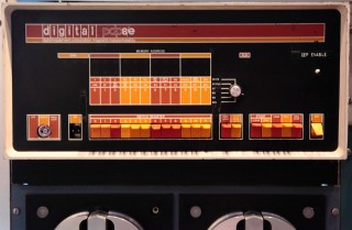
I love museums, but this was the most enjoyable one ever. It tweaked all my computer nerd nerve endings with exhibits on early mechanical computing, punched cards and the census, mainframes and minicomputers, memory technologies over the ages, robotics, Lisp machines, exotic I/O devices and of course video games. We spent five hours in there because that’s all the time we had – I could easily spend five days studying the displays in detail. Highly recommended.
Apparently we passed within 20 miles of The Woz while there, according to his twitter feed.
Riding the CalTrain to and from the museum, it was a bit surreal to realize just how many famous technology companies and tech-heavy locales are in the area – Menlo Park, Redwood Shores, Cupertino etc.
After the museum we went back downtown to try and score some good eats. We ended up going to a highly recommended (and deservedly so) Mexican place in the Mission called La Taqueria. I had a chorizo burrito, and man was it ever delicious. Then we walked over to Mitchell’s for some ice cream. The place was packed but the wait was worth it – it instantly became one of my top three ice cream parlours by virtue of its rich creamery goodness.
The next day I had lunch with friends from Vancouver who had moved down here recently, then got on a plane home.
San Francisco is a really nice city – it feels like Vancouver but is much prettier. I definitely need to go back and see more.
Overall I really enjoyed this vacation. Everything went really smoothly (for me, at least) and I did everything I wanted to do. Got some relaxation in, had some great food, saw some good sights, and most importantly got out of my routine and had some new experiences.
Whereas my last vacation (my road trip across Canada last year) was about rehashing my past, this year’s trip was chock full of new experiences and new records for me:
- Farthest west I’ve ever been: 157° 57′ W.
- Farthest into the past (GMT-10) I’ve ever been.
- Farthest south I’ve ever been: 19° 19’N.
- Doubled the number of states I’ve visited, to four.
- I realized I actually kind of like flying, so long as I can see out the window and there’s no turbulence. It’s still cheating as a form of travel, but driving to Hawaii by road is admittedly a little difficult.
- First swim in 30 years.
- First swim in the ocean.
- First time snorkeling.
- First time in the US and A since 2004.
- First shaved ice treat.
- First burrito.
- First malasada.
- First visit to an active volcano.
- Highest altitude I’ve ever been on the ground – 9000 ft.
- First time in a tropical place.
Overall: A great success!
Hawaii
I just returned from my vacation to Hawaii and San Francisco. It was a delightful trip. I’ll be posting photos in a week or so, after I’ve had a chance to go through them and clean them up.
I spent a week in Hawaii, renting a condo for a week at the Vista Waikoloa Beach Resort, which I highly recommend doing – it’s cheaper than a resort hotel, quieter, and the suites are large and comfortable. I went for this option because my friend Phloem has a place in the same building, so this made coordination easy.
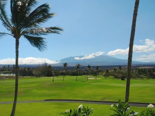
Here’s what the view from my lanai looked like. It’s adjacent to a golf course, hence the green. If I remember right, that’s Mauna Loa in the background.
The first day in Hawaii I was a bit jet-lagged and didn’t do much except sleep and go for a swim in the pool (first time I’ve been swimming in about 30 years). At the end of the day my other friend Frink had arrived from Calgary, and we were ready to rock.
The next day we drove into the city of Kailua-Kona to do some eating and shopping. We had an excellent burrito at Killer Tacos, a place tourists aren’t likely to find because it’s tucked away in a semi-industrial zone.
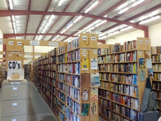
On the same block is the largest used bookstore I’ve ever been in, with a stock comparable to the sum of the excellent Fair’s Fair chain in Calgary. Frink and I spent a couple of hours in here and found a few treasures.
That evening we went for a swim in the ocean at a pretty beach near the resort.
The third day was an all-day trip to see the active volcano of Kilauea, on the other side of the Big Island. On the way, Phloem took us to Tex Drive-In for malasadas. If you haven’t had these before, you really should. They’re like a sugar-coated, creme-filled donut made with sweet bread, and served hot. You have to eat them immediately – don’t even consider warming them up later. Amazingly delicious. Possibly the best pastry ever.
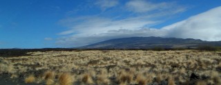
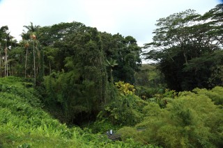
The big island of Hawaii has quite an assortment of biomes, the most notable division being between dry and rainy.
The east side of the island looks like this: old lava that has been colonized by low, hardy drought-resistant plants.
The west side is more like this – tropical rainforest. The division is so marked that in passing through the town of Waimea you literally drive in from arid scrubland on one side and come out in verdant farmland on the other, and it’s not unusual for half the town to get rained on while the other half is in the sun.
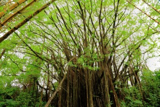
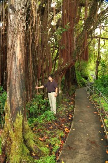
We stopped at Akaka Falls to see the tall waterfall and the lush vegetation, including the first time I’ve seen a free-growing banyan tree – huge!
It’s hard to tell from this photo just how much biomass is in this tree. Here’s a shot of Phloem posing near some of the buttress roots:
I’ll post more photos of the plant life and the waterfall in a few days.
We stopped for lunch in the city of Hilo, but the intended local dining option was closed on Sunday, so we ended up not eating anything notable.
Then it was on to the volcano.
The volcano was kind of sulking when we were there – the active lava floes were not easily accessible and we couldn’t get a direct view of the open lava in the caldera. But there were still lots of interesting things to see.
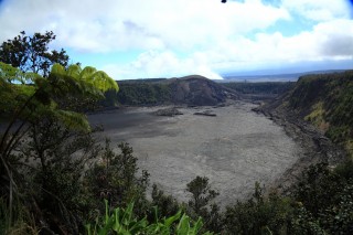
For example, this older crater on the edge of the main one. The scale of these landscapes is something we’re not used to seeing. Those walls are 40 stories high and very steep. As an attempt to show the distance to the floor, here’s a visual aid made from a wide-angle and a telephoto shot of the same scene:
We also walked through an old lava tube and saw some lava-devastated and recovering landscape – starkly beautiful. Again, pictures coming soon.
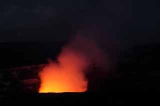
We hung around until after dark so we could at least see the glow of the lava in the caldera lighting up the smoke column:
After that it was a long after-dark drive home, punctuated with some ono grinds at Ken’s House of Pancakes. This place has an incredible variety of food – check out the menu on the website. Pancakes seem to be a thing in this area, coming big, thick and numerous. They were delicious but I barely finished half my plate.
The next day was my first time snorkeling. It took me some time to get used to the snorkel – at first it kept setting off my gag reflex. I also had a really hard time overcoming my panic at submerging my face, but using a flotation device helped a lot. We saw a middling-sized sea turtle and lots of humuhumunukunukuapua’a (I love that name) among other colorful things. Afterward I had my first shaved ice treat and we had a pretty decent locally-grown burger at Ultimate Burger.
The fifth day was the main event – the 2012 transit of Venus, which is the event that led us to schedule this trip to this place at this particular time. It was the last chance to watch Venus pass in front of the sun for the next 105 years, and we wanted to do it from up at the Mauna Kea observatory. Coincidentally, there was also a partial eclipse of the moon the previous night that I didn’t know about.
We spent the first part of the day making our own solar filters so we could photograph the sun without ruining our cameras or eyes, and we watched the first part of the transit from our home base. Then we drove up the mountain to watch the conclusion and do some after-sunset stargazing. I ended up not going to the summit – we stopped at the visitors’ center which is at 9,000 feet, and I found it very difficult to breathe there – just walking on level ground was cause for rapid panting. I probably could have survived a brief visit to the actual observatory at 14,000 feet, but it would not have been very pleasant.
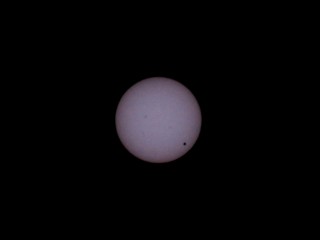
More photos later, but here’s one of my pictures of the transit. The dark spot at lower right is Venus, and I believe the smaller spots near the center are sunspots. Of course other people got much better photos of the event than I did, but I’m thrilled that I was able to get even this much with a mere 200mm lens and hand-made filters.
The final day in Hawaii we mostly rested and reflected, though Phloem did take us for a walk over to the nearby resort hotel to show us what it was like.
It’s beyond belief – three huge buildings joined by a train, with a private lake and beach, and a pool with dolphins in it that you can pay to swim with. It’s like a condensed microcosm of Hawaii in a way – pretend you were there without ever leaving the hotel. I’m glad I didn’t stay here.
Next time I’ll post about the two-day San Francisco leg of our trip. But I do want to note this:
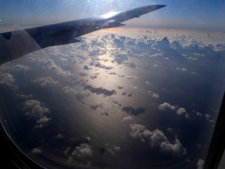
Staring out the airplane window for hours while flying over the Pacific to and from Hawaii, I noticed that there really is an awful lot of water in the ocean. I never viscerally grasped its scale before. The same is true for the atmosphere – cruising at 36,000 feet, looking way down on clouds that seem so impressive from the ground, and not being able to distinguish the large waves on the surface from each other really drives home that even though the atmosphere is relatively thin, there is still a huge amount of space in it for things that fly.
Leaving my comfort zone
… namely, Canada.
If all goes as planned, tomorrow I’m heading off to vacation in Hawaii (specifically, Waikoloa on the island of Kona) for a week and then to San Francisco for three days. Doing some volcano eyeing, Venus watching and snorkeling while in Hawaii, and tourist-nerdy stuff in Frisco.
This will be my first time outside Canada since 2004, my longest trip to the US and A, and my first time off continental North America. I hope you are suitably impressed by my effort here.
Not too worried; air travel is safe if sometimes nauseating, and I have nothing to fear but this, this, this, this, this, this, and maybe a few other things. Nothing to be concerned about.
I’m not taking a computer with me so probably not much communication going on until I return.
Trip Stats
Some random statistics about my recent road trip across Canada. All numbers are approximate, and include the June begin/end trip to Vancouver Island.
Duration: 57 days.
Distance driven: 10,600 miles or 17,000 km.
Degrees of latitude crossed: 9° 5′ 22″
Degrees of longitude crossed: 63° 15′ 57″
Flat tires: 0!
Breakdowns: 0!
Illnesses: 0!
Change in driver mass: -12 lbs.
Photos taken manually: 10,000
Photos taken automatically (by dash-cam for a timelapse movie): 358,000
Times I had to stop and change the memory card in my dash-cam: 199
Total data produced: 680GB
Expense breakdown:
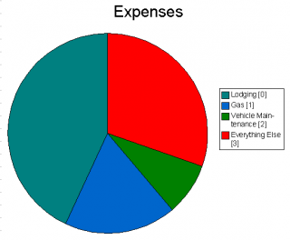
[0] The lodging figure does not include the seven nights I stayed with relatives, which would have added about another thousand dollars if it had been in hotels.
[1] Since octane ratings were downgraded last year, the Slaywagon doesn’t like regular gas much anymore, so I was buying midgrade on average.
[2] Although there were no breakdowns, I did get new brake pads, two oil changes and other preventative maintenance.
[3] “Everything Else” includes food, fares, admission charges, souvenirs and other incidental expenses. Food and souvenirs would have been the majority of it.
The total cost of the trip was about $14,000, which is both more and less than I expected. It was less in that I seemed to be spending money less quickly than I expected during the trip; most things were cheaper than I had figured. It’s more in that the total, when everything is accounted for, is larger than my most pessimistic pre-trip estimate. Shows how good I am at monitoring my spending. (Edit: I’m not confident that figure is right; mentally I can only account for about $11,000; maybe I punched something in wrong when adding things up.)
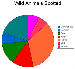
Live animals sighted (not including common birds and many dozens of snakes seen in a small area of Manitoba) (for reference, that’s one whale):
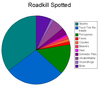
Roadkill sighted (not counting many dozens of 2D snakes spotted in a small area of Manitoba) (for reference, that’s one deer):
And here’s the overall GPS track for the whole thing. Green is eastbound, blue is westbound. The map plugin for WordPress can’t seem to handle this gracefully due to the amount of data, so here’s a link to the Google Earth file.
